What We’re Watching: 4/12/13

Posted by: Dan Watson, Public Affairs

At the end of each week, we post a “What We’re Watching” blog as we look ahead to the weekend and recap events from the week. We encourage you to share it with your friends and family, and have a safe weekend.

Monitoring Severe Weather
We continue to closely monitor the severe weather, including dangerous winds, tornadoes and severe winter weather that affected parts of the Central U.S., Midwest and Southeast, last night and Wednesday. We encourage those in affected areas to continue to monitor local radio or TV stations for updated emergency information, and to follow the instructions of state, tribal and local officials.

If you haven’t already, now is the time to get prepared for severe weather.  Visit www.ready.gov to learn more about what to do before, during, and after severe weather.

Here are a few safety tips to keep in mind should severe weather occur in your area:

  • Familiarize yourself with the terms that are used to identify a tornado hazard.
    • A tornado watch means a tornado is possible in your area.
    • A tornado warning is when a tornado is actually occurring, take shelter immediately.
  • Ensure your family preparedness plan and contacts are up to date and exercise your plan.  Learn about the emergency plans that have been established in your area by your state, tribal or local government, and ensure your home and car are prepared for the severe weather.
  • If you haven’t already, now is the time to get prepared for tornadoes and other disasters. Determine in advance where you will take shelter in case of a tornado warning:
    • Storm cellars or basements provide the best protection. If underground shelter is not available, go into an interior room or hallway on the lowest floor possible.
    • In a high-rise building, go to a small interior room or hallway on the lowest floor possible. Stay away from windows, doors and outside walls. Go to the center of the room. Stay away from corners because they attract debris.
    • Vehicles, trailers and mobile homes are not good locations to ride out a tornado. Plan to go quickly to a building with a strong foundation, if possible.
    • If shelter is not available, lie flat in a ditch or other low-lying area. Do not get under an overpass or bridge. You are safer in a low, flat location.

We will continue to monitor weather conditions as these storm systems move across the East Coast and will provide updates as necessary.

National Tribal Consultation Call
Over the past several weeks, we’ve hosted regional tribal consultation calls with tribal leadership, their organizations and stakeholders to present information regarding changes to how the federal government provides disaster assistance to tribes and how we can better meet the unique needs of Indian Country after disasters. We’ve gathered valuable comments and insights from our tribal partners related to declarations procedures and this process is culminating in a National Tribal Consultation call next week to further discuss improvements to the disaster assistance process.

Join us on Thursday, April 18 at 3:00 p.m. EDT for a National Tribal Consultation conference call and provide your comments on:

  • the Public Assistance threshold,
  • Individual Assistance declaration criteria, and
  • Cost Share adjustment for Indian Tribal governments.

Here’s the call-in information:

  • Date & Time: Thursday, April 18 at 3:00 p.m. EDT
  • Number: 888-708-5699
  • Passcode: 1601121

You can also provide your ideas and comments by visiting FEMA’s online collaboration community, or by sending us an e-mail at [email protected].

In case you missed it, Administrator Fugate recently blogged:

When you’re tackling a new and challenging topic, starting from a solid foundation is crucial to success.  Right now, there is an opportunity to change how the federal government provides disaster assistance and we’re looking for tribal leaders to help set a solid foundation for those changes…

We hope that you can take part in this opportunity to shape disaster assistance programs and processes more effectively.

Youth Preparedness Council
It’s not too late to submit an application or nominate a young leader in your community for our Youth Preparedness Council.  FEMA’s Youth Preparedness Council provides an opportunity for young leaders to share ideas and solutions to strengthen the nation against all types of disasters.

Here’s a short video from U.S. Senator Jack Reed from Rhode Island encouraging teenagers to apply to serve on the council.


Remember, the deadline to submit an application or nomination is next Friday, April 19.  So head over to Ready.gov/youth-preparedness for more information or to download an application today!

April 2011 – the Hardest in My Profession

Posted by: Jim Stefkovich, Meteorologist, Birmingham, Ala. National Weather Service

When the majority of your entire 30+ year career stretches between Georgia and Texas, you unfortunately see a lot of damage, destruction and death from severe weather.  You see so much of it that it can become numbing, humbling and saddening.

Still, nothing prepared me and National Weather Service (NWS) Birmingham for the events of April, 2011 and the weeks that followed.  The story actually begins on April 15, 2011, when 45 tornadoes occurred across Alabama along with 7 fatalities.  As a state, we all were still recovering when we realized a major and devastating outbreak of tornadoes would occur during the last week of April.

For almost a week prior to April 27th, NWS Birmingham, as well as other NWS offices, predicted this significant weather event, and by April 25th, provided numerous products and services forecasting the potential for several waves of severe weather, including violent, long-track tornadoes.  Some of these services included working with local TV stations and conducting radio interviews, numerous Emergency Management briefings on the statewide 800 MHz radio system, and providing high impact web graphics and multimedia presentations.

Within the office, plans were made to provide extra staffing on the 27th from 4 AM through the end of the event, as well as provisions for storm damage survey teams in the days after the event. The office electronics staff and Information Technology Officer (ITO) were also scheduled strategically to ensure any problems with communications or computer systems could be addressed and resolved as quickly as possible.

As a result, prior to the most intense activity on the afternoon of April 27th, key decision makers and the general public alike were alerted to the potential for a significant severe weather outbreak.  Based on information and forecasts provided by our office, numerous schools across the County Warning Area were either closed for the day or closed early, and Government agencies and businesses closed early.  By mid-morning, Governor Bentley signed a declaration of emergency in anticipation of the expected outbreak, and the Alabama State Emergency Operations Center was activated at the same level as a landfalling hurricane.

Shortly after midnight on the 27th, the first of three waves of tornadic storms occurred.  Another wave around noon.  Then the final wave during the late afternoon into the late evening.  Almost 20 straight hours of severe weather with 62 tornadoes.  Over 250 souls lost, with hundreds more injured.  Incredible, widespread damage.  109 total tornadoes in April alone, which exceeded the all-time record for an entire year!

At the NWS Birmingham office, everyone knew the stakes on April 27th.   We were focused and driven to put out the best warning and additional information to everyone.  As the third wave unfolded and it became apparent that multiple tornadoes were on the ground and people were dying because of them, some of the staff were overwhelmed with emotion and needed to be relieved for a few minutes to regain composure.  And, they did.  We became even more focused until the entire event ended.

For months after April 2011, before every severe weather event, numerous people would ask how the upcoming event would compare to the 27th.  I told them that comparisons were impossible, but just one straight line wind event, one tornado or one flash flood causing death and destruction is their and your April 27th.

You see, we at the National Weather take our role of providing life-saving information very seriously.  I get great satisfaction knowing I helped someone, and am greatly saddened when people don’t bother or care to know about impending danger. Our best forecasts and warnings mean nothing if YOU don’t do something with this information.  So, please join us.  Take this week to learn about the threats.  Learn how to receive hazardous weather alerts and updates.  Finally, develop a plan to protect yourself and others before hazardous weather strikes.  The life you save may be your own!

Responding to extreme climate even though establishing tomorrow’s leaders

Posted by: Scott Hart, Neighborhood Emergency Response Team, Rowlett, Texas

Early last April, North Texas was hit by serious thunderstorms and tornadoes. A single line of storm cells with tornadoes triggered extreme damage across at least 4 counties. In Lancaster, in southern Dallas County, far more than 300 houses have been broken by the tornadoes.&nbsp Regional resources were rapidly overwhelmed. Neighborhood Emergency Response Teams (CERT) from the North Central Texas Region responded to the contact for added aid.

Rowlett sent a team that consisted of both CERT volunteers and youth members of Rowlett Explorer Post A single (Post One includes members of a youth program chartered by way of Boy Scouts of America’s Finding out for Life Applications). The team went door to door, operating with residents to identify debris that required to be moved. Right after they identified the debris, the teams assisted in moving the debris to the street, which permitted City crews to promptly eliminate it.

volunteers pick up debris
CAPTION: Rowlett, Texas, April five, 2011 — Volunteers from the Rowlett Neighborhood Emergency Response Group and Explorer Post One get rid of tornado debris.&nbsp Explorer Post One particular is a youth system chartered via Boy Scouts of America’s Understanding for Life Applications that receives disaster response instruction.

Rowlett CERT and Explorer Post A single contributed around 345 service hours in help of the Rockwall County and City of Lancaster tornado responses.

The City of Lancaster expressed their appreciation stating,

The success of this CERT callout validates the value of our CERT programs and regional partnerships. Please pass along this appreciation to your CERT members.&nbsp

Responding to a community’s want is nothing at all new for Rowlett’s Explorer Post One. The post is closely aligned with FEMA’s new direction to develop upon the Teen CERT program. Members have been trained to help offer vital help by giving immediate help to survivors, supplying damage assessment information and organizing other volunteers at a disaster internet site. Even so, in contrast to most Teen CERT programs, the Rowlett Explorer system training goes far beyond the college atmosphere and standard education. Member education consists of CERT, Amateur Radio, CPR/AED/First Aid, climbing, rappelling, ropes/knots, National Association of Search and Rescue coaching, National Incident Management System courses, Incident Command, and other skills.

More than the past three years, the Post has contributed practically three,900 service hours in education, meetings and help.&nbsp But much more essential than the quantity of hours is the good instance of emergency preparedness the Post sets day in and day out.&nbsp The Explorer Post develops character, self-self-confidence and leadership that is central to the objective of the program. In addition to supporting emergency responders during a disaster, the Explorer system builds strong functioning relationships between emergency responders and the communities they serve. These relationships are crucial simply because effectively responding to emergencies and severe climate needs a group work – created up of the individuals, families, neighborhood leaders, organizations and businesses in each and every regional neighborhood.

The more we train our youth in these critical locations, the much better prepared our neighborhood becomes with dealing with uncommon conditions. We are not only instruction our youth in disaster preparedness, we are preparing tomorrow’s leaders. There is no greater instance of that than Rowlett Explorer Post A single, and I encourage your neighborhood to look at how you can get youth involved in disaster preparedness.

Thanks for reading and letting me share how we are a force of nature in Rowlett!

Preparing Communities for Severe Climate

Posted by: Rachel Little, FEMA Youth Council Member

Along with the advantages of witnessing the changing of New England’s beautiful seasons, residents must be ready to face a variety of severe weather conditions. My name is Rachel Little, a member of the FEMA Youth Preparedness Council, and a resident of Massachusetts. My favorite part of living in New England is the variety of activities to do like skiing and snowboarding in the winter, swimming and visiting the beach in the summer and all within just a couple hours of where I live.

While I love to enjoy the great outdoors, nor’easters, blizzards, tornadoes, hurricanes and flash floods are all dangerous hazards New Englanders have faced within the past two years. Preparing for severe weather is critically important when living here. Preparedness is imperative when a storm is approaching, though some don’t always know how to prepare for something severe. When I heard about the February blizzard approaching, I knew it was going to be a big one. One measure that our area took to prepare for the blizzard was putting a driving ban after four o’clock on the evening the storm was set to hit. All motor vehicles had to evacuate the roads or face large fines. As far as preparedness goes, I thought this was an extremely brilliant precaution and would keep many people safe. It would also make the job easier for emergency personnel working through the night. The type of snow that a storm brings makes all the difference in the world. If it’s light snow, it’s easier to deal with, less dangerous, and easier for snow removal. If it’s thick, wet, heavy snow, it makes it more difficult for all residents. It’s harder to remove, can cause severe damage to personal property and is a nightmare for men and women working for the power company. Thankfully the snow was light, but there was just a lot of it!

23590 tornado 63990

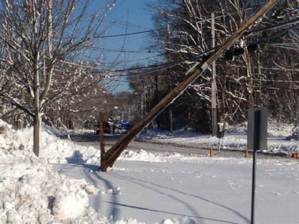
CAPTION: South Kingstown, R.I., Feb. 19, 2013 — Damage in South Kingstown following the Northeastern Blizzard.

This situation was very similar to the October snowstorm in 2011. We knew there was a possibility of snow around Halloween, but it was not forecasted to be as bad as it turned out to be. A major problem with the October 2011 snowstorm were the remaining leaves on the trees, which gave the heavy snow more of an opportunity to break branches and limbs. Trees snapped all through the night and took out power lines, leaving so many without power. My father works for National Grid, and I didn’t see him for several weeks after the storm because the power outages were so widespread.

23590 tornado 63985

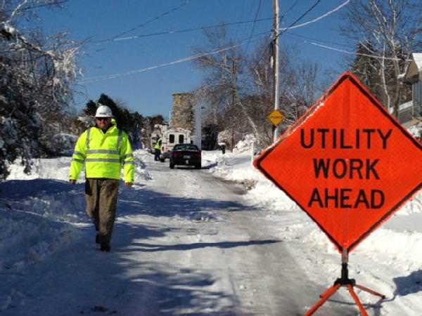
CAPTION: Narragansett, R.I., Feb. 19, 2013 — Utility workers repair downed power lines following the Northeast Blizzard. 

By far the most disastrous and destructive disaster to hit our community was the 2011 tornado that cut through Massachusetts. No one ever thought a tornado could possibly make its way to us, as we have large mountains all around us and live in a valley. I think that it is an important fact to be made known across the country, that any place is vulnerable to the attack of a vicious natural disaster at any time.

These experiences have only made disaster preparedness more important to me and make me want to be ready for anything in the years ahead. After our last blizzard in February, I have continued to spread three key factors to being prepared: know your risk, take action, and be an example for your family and community. Taking action is not only readying yourself and family members for a disastrous situation, but spreading the word to your neighborhood and throughout the community. By knowing our risk, we can greatly reduce the amount of fatalities and injuries during a disaster because we took steps to prepare beforehand. I also continue to be a champion of preparedness for all the people I care so much about. I have encouraged my family, school and community to talk about emergency plans and build a preparedness kit before severe weather hits. If we all take part in spreading the word about disaster preparedness and sharing tips, many people will be much safer if they have to go through a severe storm.

Editor’s Note: FEMA’s Youth Preparedness Council is a unique opportunity for a nominated group of youth leaders to serve on a highly distinguished national council and to voice their opinions, experiences, ideas and solutions to help strengthen the nation’s resiliency for all types of disasters.

Preparedness Matters: Preparing our Shops and Clubs for Extreme Climate

Posted by: Mark Cooper, Senior Director, Walmart Global Emergency Management

When it comes to severe weather, you never know when a thunderstorm may spawn into a deadly, destructive tornado. Considering Walmart serves more than 140 million customers in more than 4,000 U.S. locations on a weekly basis, it’s safe to say we’ve seen our fair share of bad weather.

Because of our size and scale, we cover a lot of territory and ride out a lot of storms with our fellow Americans. When there’s a weather warning, there’s usually a Walmart or Sam’s Club not too far in the distance. That’s why it’s extremely critical for us to ensure our stores and club associates know what to do when it comes to emergency preparedness and response.

As part of our commitment to emergency preparedness, our stores and clubs are set up to receive a phone call notification as soon as the National Weather Service issues a severe thunderstorm warning or a tornado watch/warning. When this happens, stores are expected to take immediate action to implement their severe weather safety plan.

It’s not only important to implement the plan, but it’s also important to review the plan on a regular basis. Case in point: About a month before the EF-5 tornado hit Joplin in May 2011, our store manager had decided to review his store’s safety plan. Andy Martin, Store Manager, and his team reviewed the store’s layout and determined the back of the store was the safest place to be in the event of a tornado. Then, he made sure that each and every associate knew how to execute the plan.

Andy was off from work the day the storm hit, but his associates knew what to do. They ran the plan. They alerted customers to huddle in the back of the store which was pre-determined as the safe zone. Their quick actions in working the plan ultimately helped to save more than 200 lives.

We take safety into account in everything we do. That includes identifying safe zones for every facility we have. Because locations vary, what is an appropriate safe zone for one store may not be appropriate for another. For example, we realize that the designated zone for Joplin, MO may not be the designated zone for every store. More importantly, we realize severe weather is unpredictable so we focus our energy on preparing our associates. By providing them with safety protocols and enabling them to develop an emergency plan for work and home, we’re helping them to be ready for the unexpected.

During National Severe Weather Preparedness Week, we encourage you to put together an emergency plan for your family and your business. Whether you are facing severe weather, a fire in your home, a utility outage in your workplace, or any other emergency, developing a preparedness plan will make you, your family and your employees more resilient. Walmart hopes you will take action by pledging to prepare for the unexpected at work and at home.

Severe Weather throughout the South & Midwest

Posted by: Lars Anderson, Director, Public Affairs

As the risk for severe weather conditions continue throughout parts of the Midwest and South, we wanted to take a second to remind everyone in areas expected to see severe weather to take necessary precautions now. We encourage all individuals in areas where severe weather is expected to listen to NOAA Weather Radio, especially as we head into the evening and overnight, and local news for severe weather updates and warnings and to always follow the direction provided by their local officials.

Here are a few severe weather terms you should familiarize yourself with now:

  • Severe Thunderstorm Watch – Tells you when and where severe thunderstorms are likely to occur. Watch the sky and stay tuned to NOAA Weather Radio, commercial radio or television for information.
  • Severe Thunderstorm Warning – Issued when severe weather has been reported by spotters or indicated by radar. Warnings indicate imminent danger to life and property to those in the path of the storm. 
  • Tornado Watch – Tornadoes are possible. Remain alert for approaching storms. Watch the sky and stay tuned to NOAA Weather Radio, commercial radio or television for information. 
  • Tornado Warning – A tornado has been sighted or indicated by weather radar. Take shelter immediately. 

As weather conditions often change quickly, it’s important to stay updated on your local forecast conditions at weather.gov (or mobile.weather.gov on your mobile device).

If severe weather is expected in your area, keep in mind these safety tips:

  • Continue to monitor your battery-powered radio or television for emergency information. 
  • Do not touch downed power lines or objects in contact with downed lines. Report downed power lines and electrical hazards to the police and the utility company. 
  • Injury may result from the direct impact of a tornado or it may occur afterward when people walk among debris and enter damaged buildings. Wear sturdy shoes or boots, long sleeves and gloves when handling or walking on or near debris. 
  • After a tornado, be aware of possible structural, electrical or gas-leak hazards in your home. Contact your local city or county building inspectors for information on structural safety codes and standards. They may also offer suggestions on finding a qualified contractor to do work for you.

Visit www.ready.gov/severe-weather  for more tips on what to do if severe weather is expected in your area. You can also visit http://m.fema.gov for safety tips on your mobile device.

Hurricane Sandy Statistics

By Andrew Freedman

Hurricane Sandy obliterated many records along the East Coast, from its extraordinarily low air pressure to the storm surge. In some ways it was even worse than a worst-case scenario.

Here is a roundup of some of the staggering statistics.

Hurricane Sandy StatisticsAir Pressure Records:

– Sandy had a minimum central pressure of 946 mb when it made landfall, which was the second-lowest pressure of any storm to come ashore north of Cape Hatteras, N.C. Only the Hurricane of 1938 had a lower air pressure reading at landfall that far north, which was 941 mb. In general, the lower the air pressure, the stronger the storm.

– Atlantic City, Baltimore, Philadelphia, and Trenton, N.J., all set records for the lowest air pressure reading ever recorded. At Atlantic City, which was close to the storm’s landfall location, the pressure fell to 945.6 mb, smashing the record of 961 mb, set in 1932. In Philadelphia, the pressure dropped to 953 mb, which broke the old record of 963 mb set during the “Superstorm of 1993.”

What’s noteworthy about these air pressure records is that they show that the storm was even more intense than aworst-case scenario studied by MIT’s Kerry Emanuel and Princeton’s Michael Oppenheimer. They published a study in June that warned of New York City’s vulnerability to storm surge flooding, but the storm they modeled had a minimum central pressure of about 960 mb at landfall. In other words, their worst-case scenario storm wasn’t as intense as Hurricane Sandy turned out to be.

Storm Surge

As expected, the extremely powerful storm surge proved to be Hurricane Sandy’s fiercest weapon, as water overwhelmed defenses throughout coastal New Jersey, New York City, Connecticut, and Rhode Island.

Here are some of Sandy’s most significant storm surges – measured as feet above the average low tide:

14.38 feet – Kings Point, N.Y.

13.88 feet –  The Battery, Lower Manhattan, which included a storm surge component of 9.23 feet. (Put another way, the water level at The Battery rose to 9.15 feet above the average high-tide line.)

13.31 feet – Sandy Hook, N.J. (Put another way, the water level at Sandy Hook rose to 8.1 feet above the average high-tide line.)

The storm surge at The Battery broke the old record, which was recorded during Hurricane Donna in 1960. It also broke the record of 11.2 ft. from a powerful hurricane that struck the region in 1821. Note that the Sandy Hook gauge stopped recording at 13.31 feet, so the actual highest water level was very likely higher than that.

Winds:

High winds affected the entire eastern third of the country, creating whitecaps on the surface of Lake Michigan at the same time that the Atlantic Ocean was still inundating coastal communities in the Mid-Atlantic states. Here are some of the strongest gusts:

90 mph – Islip, N.Y.
90 mph – Tompkinsville, N.J.
86 mph – Westerly, R.I.
83 mph – Cuttyhunk, Mass.
81 mph – Allentown, Pa.
80 mph – Newark, N.J.
79 mph – JFK Airport, N.Y.

Rain and Snow:

Unlike Hurricane Irene in 2011, Sandy did not produce devastating inland flooding, in part because it dropped less rain, and also because the Northeast and Mid-Atlantic had been quite dry leading up to the event. Still, there were some formidable rainfall totals, such as 12.55 inches in Easton, Md., and 11.91 inches in Wildwood, NJ.

One of the most unusual aspects of this enormous storm was the crippling amount of heavy, wet snow it produced in the higher elevations of Maryland, Pennsylvania, Tennessee, Virginia, West Virginia. Snow also fell in parts of Ohio. During a media conference call as Sandy was nearing landfall, Louis Uccellini, a leading expert on snowstorms and the director of the National Center for Environmental Prediction in College Park, Md., said he knows of no previous hurricane that also dropped such heavy snow.

Here are some of the highest snow totals:

34.0 in. – Gatlinburg, Tenn.
33.0 in. – Clayton, W. Va.
29.0 in. – Redhouse, Md.
24.0 in. – Norton, Va.

New York Stories in the Wake of Sandy

Editor’s note: This was originally posted on the U.S. Dept. of Labor Blog.

No television image or news report can prepare you for this.

Families without power—unable to shower or wash their clothes for days—huddled together in churches serving as “warming centers” to provide refuge from the stinging cold outside…

sandy damage piles

Secretary Solis toured a hard hit area of Queens where flood waters and sand took their toll on the neighborhood.

Mounds of displaced sand plowed two stories high in residential neighborhoods, so homeowners could finally get through their front door to survey the damage inside…

Mothers with shopping baskets, and dads holding plastic bags, sifting through donation boxes at makeshift relief centers to find food and clothing to keep their children nourished and warm….

Wine sellers, florists, glass etchers, caterers, printers and other merchants surveying the wreckage of their small businesses, navigating knee-high dirty water to strip off drywall before dangerous mold forms, spreads and creates a health risk….

I spent yesterday in Brooklyn and Queens because the federal government has a responsibility here. It’s not enough to just send our thoughts and prayers.

Solis at Food Bank

Secretary Solis chats with a small child while his family collects needed food and clothing supplies.

President Obama told every member of his cabinet to work quickly to deliver critical aid wherever it’s needed. That’s why I exercised my discretion and approved $27.8 million under our National Emergency Grant program to fund 1,400 temporary jobs for New Yorkers to assist with clean-up efforts in the five boroughs. We cut the red tape and approved the funding less than 24 hours after it was requested.

I also approved $15.6 million for cleanup crews in New Jersey and $1.5 million for Rhode Island. As additional requests for assistance come in to the Department of Labor, they will be handled immediately. We also are providing emergency disaster unemployment insurance to affected workers who may not normally qualify, such as part-time and new workers.

Solis and Meeks

During a visit at the Queens Workforce 1 Career Center (One Stop), Secretary Solis met with community leaders and Congressman Gregory W. Meeks to discuss grants to hire workers for clean up efforts.

There has been enough suffering, so we’re communicating the safety precautions for clean-up workers to take as they rebuild. They should assume all power lines are live, and act with appropriate caution. And they should wear hard hats, shoes and reflective vests, and follow proper safety procedures when using ladders, cutting down trees and working near other hazards. The Labor Department’s Occupational Safety and Health Administration officials are on the ground in all of the affected areas, providing training and educational materials so crews stay safe as they restore electricity, demolish structures, clear debris and repair infrastructure.

Even in the face of so much adversity, I also saw many scenes yesterday that left me inspired. I saw that rough-and-tumble New Yorker stereotype give way to countless demonstrations of kindness and sacrifice. I saw people more concerned about their neighbors than themselves.  They were standing elbow to elbow in food lines. They knew there was a finite amount of food, but they waited patiently. No one pushed or jostled. In fact, I saw people at the front of the line passing sandwiches back to the people behind them.

Solis at Sandy class

Make the Road New York, one of the groups visited by Secretary Solis has been collecting and distributing donations.

As always, the faith community sprang into action: At Blessed Virgin Mary Parish in Brooklyn, a priest who looked like he hadn’t slept in days delivered comfort to people of every race, religion and background. “I’m going to pray for your strength,” I heard him say. St. Francis de Sales Catholic Church in Queens welcomed Jewish congregants so they could hold Sabbath services Friday night after their temple had been damaged in the storm.

I saw FEMA crews working side by side with state and local officials. Instead of turf wars or acrimony, there was a clear sense of shared purpose. I saw businesses like Lowe’s on sight with hundreds of buckets to help with debris removal. Relief workers brought canned goods. Local grocers supplied fresh fruit and sandwiches. As I was leaving, I saw the Army Corps of Engineers bringing in generators to provide power and warmth.

I will never forget the people I met or the unlikely scenes of hope that transpired in the midst of so much hardship and loss.  Long after the camera crews are gone, the rebuilding will continue. This government—and this department—will be there until the work is complete. In times like this, we are one.

Hurricane Sandy Recovery Efforts

Author: Craig Fugate

One week ago today, millions of Americans from North Carolina to Maine braced for Hurricane Sandy.  That evening for over 12 hours, hurricane and tropical storm force winds, storm surge, and flooding impacted 12 states, with over eight million people losing power. Transportation systems in New York, Philadelphia, Boston, and Washington, DC came to a halt, and more than 12,000 commercial flights were grounded.  And for the first time since 1888, the New York Stock Exchange was closed for two consecutive days because of a natural disaster.

Days before the storm stuck, at the direction of President Obama, the entire federal government was mobilizing to support the anticipated state and local response to the storm.  The President declared an emergency in over a dozen states, and resources and commodities like food, water and blankets were pre-positioned.  FEMA staff was deployed to work side-by-side with their state and local counterparts to ensure coordination in response to the impacts of the storm, and urban search and rescue teams were deployed to prepare to support state and local efforts.  First responders up and down the east coast knocked on doors to urge those in danger to get out of harm’s way.

Before the tropical storm force winds stopped blowing on Tuesday, President Obama had declared a major disaster declaration for the states of New York and New Jersey, immediately making federal financial assistance available to individuals in the impacted regions.  As of this afternoon, over 230,000 individuals in the impacted areas have registered for financial assistance, and over $210 million has been provided to survivors.

We know that the human and economic toll of Hurricane Sandy will be severe and long-lasting.  More than 100 people lost their lives and were victims of this storm – they will not be forgotten.  In addition, there were billions in losses to small businesses and personal property.  But out of this tragedy, there are stories of survivors pulling together, neighbors helping neighbors, and communities beginning to rebuild.

We know that there are many challenges ahead and that recovery will not happen overnight.  Many survivors remain without power, and many are finding themselves without shelter.  FEMA will remain in support of our state, tribal and local partners, 24 hours a day, seven days a week.  Even as television cameras turn to other stories, we will be on the ground to support the survivors.

If you are a survivor, it’s important to take that the first step is to register with FEMA, by calling 1-800-621-FEMA or going online to www.disasterassistance.gov on your computer or mobile device.

As we have seen in the past few days, a disaster can happen to any of us, but by working together as one team, we can recover and we can rebuild.

Sandy Update 6: Registering for Assistance, Over $100 million Already Approved for Disaster Survivors

Author: Lars Anderson

As many people across the Northeast and Mid-Atlantic continue to recover from Hurricane Sandy, members of the entire emergency management team, including the federal, state, tribal, and local governments, the faith based and non-profit communities, and the public, are working tirelessly to support those across the impacted area.  As of this morning, more than 122,000 people have registered for disaster assistance and more than $107 million in assistance has already been approved.  Here’s a breakdown of disaster assistance by state:

  • New York: over  69,000 registered; more than $75 million in assistance approved
  • New Jersey:  over  49,000 registered; more than $31 million in assistance approved
  • Connecticut:  over 2,400 registered; more than $368,000 in assistance approved

These numbers continue to increase as residential power is being restored and those affected are able to register for assistance with FEMA online, as well as through the 800 number.  If you’ve live in an eligible county and have been affected by Hurricane Sandy, we encourage you to apply for assistance by calling 1-800-621-FEMA(3362) TTY 1-800-462-7585 or if you have access to the internet, applying online atwww.disasterassistance.gov.

Additionally, as many people have been without power for several days, fuel continues to be a top priority for FEMA. Under direction of President Obama, the Defense Logistics Agency (DLA) purchased up to 12 million gallons of unleaded fuel and up to 10 million gallons of diesel fuel for distribution in areas impacted by the storm to supplement ongoing private sector efforts.  Tanker trucks have distributed fuel throughout New York, New Jersey and other communities impacted by the storm. There are currently 10 fuel sites throughout New York and New Jersey where residents can refuel their cars and get gas for generators and other necessities.  We are committed to continuing our support in Hurricane Sandy response and recovery efforts.

Here are some photos highlighting our ongoing response and recovery efforts as we work to assist those residents affected by Hurricane Sandy.

Pleasantville, N.J., Oct. 31, 2012 -- At the Red Cross shelter at Pleasantville High School, FEMA Community Relations team member Sandy Hendrix talks with evacuee Lee Davidson about his immediate needs.

Pleasantville, N.J., Oct. 31, 2012 — At the Red Cross shelter at Pleasantville High School, FEMA Community Relations team member Sandy Hendrix talks with evacuee Lee Davidson about his immediate needs.

Atlanta, Ga., Oct. 31, 2012 -- Through distribution centers in Atlanta, Ga. and Frederick, Md., FEMA maintains commodities, including millions of liters of water, millions of meals and hundreds of thousands of blankets. As of last evening, more than 305,000 liters of water and more than 185,000 meals in staging at Incident Support Bases in Westover, MA and Lakehurst, NJ, have been transferred to states to supplement their existing inventory. The Incident Support Bases continue to be restocked in anticipation of additional requests for assistance from affected states.

Atlanta, Ga., Oct. 31, 2012 — Through distribution centers in Atlanta, Ga. and Frederick, Md., FEMA maintains commodities, including millions of liters of water, millions of meals and hundreds of thousands of blankets. As of last evening, more than 305,000 liters of water and more than 185,000 meals in staging at Incident Support Bases in Westover, MA and Lakehurst, NJ, have been transferred to states to supplement their existing inventory. The Incident Support Bases continue to be restocked in anticipation of additional requests for assistance from affected states.

Riverside, Calif., Nov. 1, 2012 -- A fleet of more than 70 Southern California Edison utility trucks is being prepared for transport to the East Coast to help restore power in areas devastated by Hurricane Sandy. The U.S. Air Force will use six C-5 and eight C-17 aircraft to transport the vehicles from March Air Reserve Base in Riverside County.

Riverside, Calif., Nov. 1, 2012 — A fleet of more than 70 Southern California Edison utility trucks is being prepared for transport to the East Coast to help restore power in areas devastated by Hurricane Sandy. The U.S. Air Force will use six C-5 and eight C-17 aircraft to transport the vehicles from March Air Reserve Base in Riverside County.

Hoboken, N.J., Nov. 1, 2012 -- FEMA Deputy Administrator Richard Serino is shown damaged businesses in Hoboken, New Jersey by Hoboken Mayor Dawn Zimmer. Hurricane Sandy damaged hundreds of businesses and left most of the town under water.

Hoboken, N.J., Nov. 1, 2012 — FEMA Deputy Administrator Richard Serino is shown damaged businesses in Hoboken, New Jersey by Hoboken Mayor Dawn Zimmer. Hurricane Sandy damaged hundreds of businesses and left most of the town under water.

Hoboken, N.J., Nov. 1, 2012 -- FEMA Community Relations team member Nancy Evans talks with a cleanup volunteer from Hoboken Grace Church. FEMA is working with many partners and organizations to provide assistance to residents affected by Hurricane Sandy.

Hoboken, N.J., Nov. 1, 2012 — FEMA Community Relations team member Nancy Evans talks with a cleanup volunteer from Hoboken Grace Church. FEMA is working with many partners and organizations to provide assistance to residents affected by Hurricane Sandy.

Hoboken, N.J., Nov. 1, 2012 -- FEMA Community Relations team member Joanne Doaring talks with residents Teresa Brenda and Chris Skarantonakis about meeting their immediate needs for food and safe shelter. FEMA is working with many partners and organizations to provide assistance to residents affected by Hurricane Sandy.

Hoboken, N.J., Nov. 1, 2012 — FEMA Community Relations team member Joanne Doaring talks with residents Teresa Brenda and Chris Skarantonakis about meeting their immediate needs for food and safe shelter. FEMA is working with many partners and organizations to provide assistance to residents affected by Hurricane Sandy.

Hoboken, N.J., Nov. 1, 2012 -- FEMA Community Relations team member Ray Vees talks with residents John and Debra Veloce about registering with FEMA after Hurricane Sandy flooded their apartment. FEMA is working with many partners and organizations to provide assistance to residents affected by Hurricane Sandy.

Hoboken, N.J., Nov. 1, 2012 — FEMA Community Relations team member Ray Vees talks with residents John and Debra Veloce about registering with FEMA after Hurricane Sandy flooded their apartment. FEMA is working with many partners and organizations to provide assistance to residents affected by Hurricane Sandy.

Queens, N.Y., Nov. 1, 2012 -- FEMA Community Relations (CR) team members moved through Breezy Point and Rockaway, NY, after Hurricane Sandy. The CR members talked with disaster survivors about FEMA assistance and assessed the situation on the ground.

Queens, N.Y., Nov. 1, 2012 — FEMA Community Relations (CR) team members moved through Breezy Point and Rockaway, NY, after Hurricane Sandy. The CR members talked with disaster survivors about FEMA assistance and assessed the situation on the ground.

Staten Island, N.Y., Nov. 2, 2012 -- FEMA Deputy Administrator Rich Serino, left, and DOE Deputy Assistant Secretary William Bryan, participate on a conference call with NRCC operations from FEMA headquarters to discuss operations for Hurricane Sandy.

Staten Island, N.Y., Nov. 2, 2012 — FEMA Deputy Administrator Rich Serino, left, and DOE Deputy Assistant Secretary William Bryan, participate on a conference call with NRCC operations from FEMA headquarters to discuss operations for Hurricane Sandy.

Charleston, W.Va., Nov. 2, 2012 -- Members of the West Virginia Air National Guard unload food supplies shipped into the state by FEMA effort to support residents impacted by the storm that brought deep snow, heavy rain and high winds to the area. The supplies are moved from the staging area at Charleston's Yeager Airport to distribution points around the state.

Charleston, W.Va., Nov. 2, 2012 — Members of the West Virginia Air National Guard unload food supplies shipped into the state by FEMA effort to support residents impacted by the storm that brought deep snow, heavy rain and high winds to the area. The supplies are moved from the staging area at Charleston’s Yeager Airport to distribution points around the state.

Staten Island, N.Y., Nov. 2, 2012 -- FEMA Deputy Administrator Rich Serino, left, and Department of Homeland Security Secretary Janet Napolitano, speak to local residents at a shelter set up at Susan Wagner high school. The shelter is set up to assist residents impacted by Hurricane Sandy.

Staten Island, N.Y., Nov. 2, 2012 — FEMA Deputy Administrator Rich Serino, left, and Department of Homeland Security Secretary Janet Napolitano, speak to local residents at a shelter set up at Susan Wagner high school. The shelter is set up to assist residents impacted by Hurricane Sandy.

Cape May, N.J., Nov. 2, 2012 -- Jane Menear talks with FEMA employee Lois Bridges at the FEMA Disaster Recovery Center. People affected by Hurricane Sandy can come in and talk to various federal, state and local representatives about questions they have during the recovery process.

Cape May, N.J., Nov. 2, 2012 — Jane Menear talks with FEMA employee Lois Bridges at the FEMA Disaster Recovery Center. People affected by Hurricane Sandy can come in and talk to various federal, state and local representatives about questions they have during the recovery process.

Charleston, W.Va., Nov. 2, 2012 -- Pallets of meals brought by to West Virginia by FEMA for state residents impacted by snow, rain and high winds are prepared for distribution at the Air National Guard Base here. State and local officials are selecting sites to distribute the commodities to residents

Charleston, W.Va., Nov. 2, 2012 — Pallets of meals brought by to West Virginia by FEMA for state residents impacted by snow, rain and high winds are prepared for distribution at the Air National Guard Base here. State and local officials are selecting sites to distribute the commodities to residents.

Staten Island, N.Y., Nov. 3, 2012 -- Tanker trucks distribute fuel to residents in New York who were affected by Hurricane Sandy. The Defense Logistics Agency (DLA) purchased up to 12 million gallons of unleaded fuel and up to 10 million gallons of diesel fuel for distribution in areas impacted by the storm to supplement ongoing private sector efforts.

Staten Island, N.Y., Nov. 3, 2012 — Tanker trucks distribute fuel to residents in New York who were affected by Hurricane Sandy. The Defense Logistics Agency (DLA) purchased up to 12 million gallons of unleaded fuel and up to 10 million gallons of diesel fuel for distribution in areas impacted by the storm to supplement ongoing private sector efforts.

Freehold, N.J., Nov. 3, 2012 -- Tanker trucks distribute fuel throughout New York, New Jersey and other communities impacted by the storm. FEMA is working with many partners and organizations to assist residents affected by the storm.

Freehold, N.J., Nov. 3, 2012 — Tanker trucks distribute fuel throughout New York, New Jersey and other communities impacted by the storm. FEMA is working with many partners and organizations to assist residents affected by the storm.

For more photos on our response and recovery efforts, visit our Photo Library and for more information on Hurricane Sandy, visit the Hurricane Sandy page.